I recently took a quick drive over to Wells State Park to take a little walk in the wood. Wells is located in Sturbridge, Massachusetts and boasts a large number of camping, RV, and yurt sites. It also has a lake for recreational boating and fishing. You can read all about it on the mass.gov site. Wells has a smaller trail system than Leadmine Mountain / Heins Farm (which I wrote about in my last post) but there is a nice loop that takes you by Carpenters Rocks. Carpenters Rocks offers nice views of the park and is on a side trail off the main loop.
 When you enter on the main entrance, you have to drive a mile or so to reach the main parking lot. There is a fee ($5 for MA, $10 for non-MA) but I wasn’t charged. I believe it is waived after Labor Day but I’m not sure. The hiking trails don’t come right off the main parking so I drove a bit north around the loop road. Many of the campsites are around this road so you might see campers, RVs, etc. I parked right at the trailhead for the North Trail and did the loop from the North to South Trails and then walked up the road back to my car. According to the map, this would have been ~4.4 miles on the trail but my FitBit clocked in just under 3, including the brief walk on the road. I’ll have to pay more attention next time to see what the mileage actually was. I also took the side trail to Carpenters Rocks so something is off on the distance.


The hike was good, with some ups and downs, but nothing too strenuous. The trail was in decent shape although some trail maintenance has fallen behind. There were a number of downed trees that had been there for some time. Hikers have walked around them, forming new trails, as the intended route was blocked. I also found the blazes to be a bit misleading. Each trail is represented by a single color but many overlap so there are combinations of blazes on single trees. When I first started out, I thought the trail was a combination of colors so I got confused and relied on the trail map rather than the blazes. The color codes listed on the pic above weren’t on my printed copy – or I simply missed them! The trails cross some power lines in a couple places which makes for some good views in either direction. It was very hot though so I didn’t linger in the open space, preferring instead the cool of the woods.


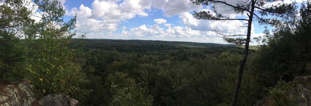
Throughout the loop, you may hear gun shots but fear not, it is simply nearby Hamilton Rod and Gun Club. I don’t know if hunting is allowed in Wells but if it’s in season, be in bright colors anyway, just to be safe. I definitely recommend taking the trail up to Carpenters Rocks. The views from there are great and while it was cloudy the day I went, visibility was still very good. This hike up to the Rocks are the steepest of any of the trails but it isn’t very long at all. There is a clearing at the top that would be suitable for tents but I don’t know if you’re allowed to camp up there. There’s enough of a breeze to keep the bugs down so it would be a great spot if you could!
I enjoyed my hike and would like to come back to do the loop that is down by Walker Pond. It would be nice if there were connections between the loops so you could turn it into a longer hike – and being able to avoid hiking on the roads would be nice. Still, if you’re looking for a quick hike, Wells surely fits the bill.


