The combination of trail systems at Leadmine Mountain and Heins Farm are the trails I consider to be my home base. I have logged many miles in these woods and rarely need to consult a map any more. Located in Sturbridge, MA, these trails aren’t crazy in terms of elevation but offer great hiking and even a few views out over the surrounding towns. They are busy at times near the trailheads but as you get deeper in, the crowds thin out and they deliver on the solitude I love.


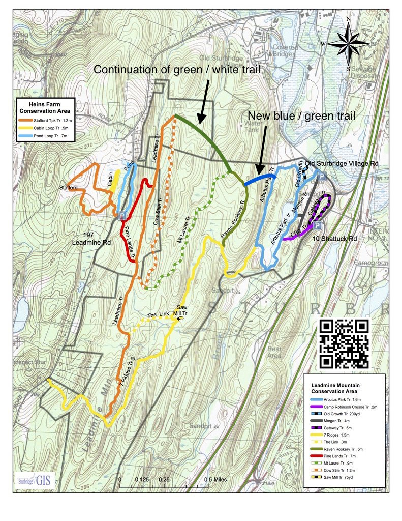
There are a vast number of loops and combinations that can be constructed from the trails. Depending on the distance you’d like, you can complete a short hike or go around the outer perimeter for nearly 8 miles. The trails are well groomed (wider, crushed gravel) near the entry points but become narrower and simply worn paths in the interior. I much prefer the latter so I tend to move away from the trailheads and nearby loops in order to make my way to the more secluded spots. Upkeep throughout these trails is wonderful – a huge thank you to all the trail maintainers out there, you work is greatly appreciated! There are good bridges and raised walkways in wet or muddy sections and the markers throughout are obvious and plentiful. Its doubtful anyone could get lost! Side note, there are two trails that have been cut in the past couple years that don’t appear on the maps at the trailheads. I’ve done my best to draw them on the map pics below.
Another aspect of these trails that I love are the little things that people have placed along the way. I have found small rocks painted with inspirational sayings, small gnome houses randomly placed next to a trail, a heart on a felled trees, and even a fairy village! The last is an official part of the trail and is open to all to construct homes for our little forest friends. There are also a couple historical markers about the area. An old toll road known as the Worcester-Stafford Turnpike once went through Heins Farm. It was privately funded and stretched from Worcester to Hartford – so says the plaque.


My favorite route to take is the long loop around the perimeter – who wouldn’t want more time in the woods? I start at the Old Sturbridge Village Parking and hike south on the Morgan Trail (gray on the map below). I hook up with the Camp Robinson Crusoe Trail (CRC, purple) and take that southwest to the Arbutus Park Trail (light blue). This trail borders a lake in this section and I take it around the southern end of the lake and jump on the 7 Ridges Trail (yellow). I take the 7 Ridges Trail all the way up to the Leadmine Trail (orange). This intersection is easy to miss, at least for me, but I look for the bowling pin on the left side of the trail. I then hike north on the Leadmine Trail and fork left onto the first intersection with the Pine Lands Trail (red). Turn northwest, walk through the parking lot and cross over Leadmine Road. I’ve now passed into the Heins Farm Conservation Area from the Leadmine Mountain Conservation Area. I take the Stafford Turnpike Trail loop (orange) and will toss in the Pond Loop Trail (light blue) just for some extra mileage. I cross back over Leadmine Road and the parking lot and take the Pine Lands Trail (red) north. This trail forks about 100 feet from the parking lot. Go left. I then take a left onto the Leadmine Trail (orange) and connect with the new section of the Mountain Laurel Trail. This trail is green on the map below but is marked green / white dashed on the trail blazes. I couldn’t figure out how to do green and white dashes on the pic! From the Mountain Laurel Trail, connect with the Raven Rookery Trail (green). From the Raven Rookery Trail, take a left onto the new green / blue blazed trail (not sure of the name). Take a left onto the Arbutus Park Trail (blue) and walk back to the parking lot. As you walk the Arbutus Park Trail, you will see a large solar field in front of you as the trail turns east. You can walk toward that solar install (theres a path worn by folks although I don’t believe it’s official). You walk east along the chainlink fence and loop around to the parking lot. You end up walking around the back side of a stockade fence section with the fire road sign. My Fitbit measures this at 7.75 miles. Not sure how accurate that is but I do it in a little under 3 hours and my normal flat land pace is 3 miles / hour so it’s close.
I also do much shorter loops depending on time – there are a ton of options. I really love this section of trails and am so happy to have them nearby!


Love the little things, too!
LikeLiked by 1 person